Question Mercatorian Authority


In 1974 German cartographer Arno Peters developed a projection that ignited a firestorm by introducing a map that far more accurately portrays land-area distribution on planet Earth.

Listen Bill, firestorms hurt innocent people. It’s not nice to start fires; however, if we may say one good thing  about firestorms: they just might melt the snowflakes who start them.


do_not_question_authority_by_graffitiwatcher

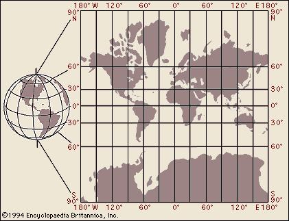
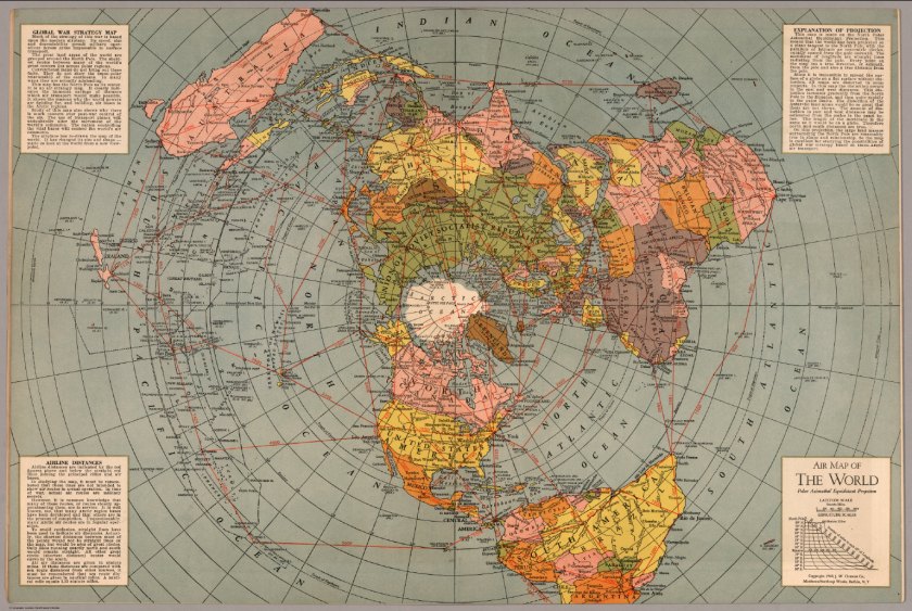
All projections are approximations — you peel the surface of a sphere and press the peels onto a two-dimensional surface. Each attempt compromises something, but that god-awful Mercator (invented in the year 1569) compromises everything except convenience for sextant users in the year 2017.

The higher the latitude, the more profound the misrepresentation. Now what value could that have for propagandists? None I guess.

There must be something worthwhile in a technique that has survived 500 years of history, Bill. We think you have too much time on your hands. Watch some March Madness, Bill.

Yesterday my son turned me on to Cartographers for Social Equality — a cult classic from The West Wing episodes.

Bill, this sounds like something you could put on a business card to alert the innocent of the foolish views that seem to stick in your craw. Can we help you get the help you need?

WordPress uses the Mercator for data analytics by country.  Canadian and Russian visitors make me feel globally successful, simply by dint of all that map-shading.

I’m still waiting for visitors from Grønland (grøn is Danish for green). For no reason at all let me tell you that the German for green is grün.

Stay on task. Do your job. Sit down and shut up. Capiche?

What of those massive islands in Northern Canada? They are actually tiny islands. Take a look at a globe the next time you’re in a furniture store. Observe how the lines of longitude join at the North and South Poles —those antipodes are infinitely distant from the Equator. Literally. Only the places close to 0º depict areas accurately — the North Pole on a Mercator is as impossible to reach as the mythical elvish workshop.

mercator.brittanica

Geography glommed many generations ago into a mash-up called branches of social science. In effect a spattering of soundbites in an already watered-down curriculum.

Here are two of many remarkable cartograms by Benjamin Hennig that you can access on his website: viewsoftheworld.net. You can directly compare area and population density for the insight that this brings — if you’re into this kind of thing.

USelection2016Cartogram

We’re not ‘into’ things. We’re on to things — we’re on to you.
The map on the right resembles a vascular circulatory system, doesn’t it? Perspective matters perhaps.
EUreferendumCartogram
Read Hennig’s blog for more cartograms that portray other dynamics at play.

The Guardian published an annotated series for comparing map projections in 2009.

Why reinvent something that Mercator already settled 500 years ago? But you have to be different, don’t you?

Thanks for reading.


Halper’s Book “War Against the People”

Cincinnati is on the Map: May 18 2016

Steady readers of billziegler1947 have now seen the name Jeff Halper appear frequently.

It is my privilege to continue bringing ICAHD and the Matrix of Control into the conversation.

jeff.halper.in.winnipeg

If this blog serves only to introduce you to Dr. Halper it has succeeded. While I am on an imagined roll, please consider finding a 1 hour 40 minutes open time slot in your viewing schedule for his talk in Winnipeg Manitoba from July 8, 2015. (Transforming Palestine into a Binational Independent State).

Excerpt:

“He is coordinator of the Israeli Committee Against House Demolitions and a leading figure in the Israeli peace movement. Nominated for the 2006 Nobel Peace Prize, Dr. Halper has published several books and many articles while working tirelessly for peace, justice and public awareness, often using non-violent direct action.Transforming Israel-Palestine into a Binational Democratic State.”

Now for new business: the Cincinnati Palestine Solidarity Coalition. is sponsoring Dr. Halper on his current book tour. Click the link at the bottom of this post for updated details.

war.against.the.people

Dr. Halper has good memories of the metropolis I write in. It’s a fortune of geography and history that we both graduated from educational institutions with international reputations: Jeff at Hebrew Union College and I at the University of Cincinnati Department of Geography. Both schools on the same street, and we graduated in the same year 1969.


map.of.cincinnati
Source: HistoryNYC.com

Please make a pilgrimage to Cincinnati if you are anywhere near. Of course you can also read more about it right here and at the link below.

Source: War Against the People

Africans without Europeans

uncolonized.africa.upside.down

What’s wrong with this map? What’s right? What’s just? Who decides? Who benefits?

Maps are important ways to perpetuate a Big Lie.  Here is Africa from a fresh perspective.

Alkebu-lan is Arabic for “Land of the Blacks.” The map above uses familiar color and shading schemes to name the distinct cultures and people. Human geography.

Zoom in and experience the fractal quality of intense diversity:

sokoto_etcetera
Sokoto Kuilafat surrounded by neighbors. Please read Big-think perspective


The unlabelled land mass at the bottom is the uninhabited realm of lands depopulated by an extinction level event such as Black Death: an alternate history suggested by Frank Jacobs elucidated here:

Africa, Uncolonized: A Detailed Look at an Alternate Continent

A few interesting land areas stand out: places Empire Expanders call Sinai, Levant, Sicily and Spain. Their unexpected presence gives pause.

Please look at this planet from the Other’s perspective, remembering that you too are the “Other.” Call me Ishmael.

The equator is the dashed line. To my eye that great lake in  Alkebu-lan looks like a chick’s eye. What a strikingly different way to look at this enormous continent. The solar system doesn’t have a top and bottom, so I can just imagine visitors from another star system mapping the southernmost continent as the top of the third planet out.

The Latin for the interior sea is Mediterranean: the sea at the middle of Earth. It’s natural but unfortunate to look at the world from where you name “us.” It could be New  York or the Middle Kingdom (China) or Middle Earth.

Anywhere, really.

America must not remain the center for geopolitical advantage studies.

The land of the fulsome and the home of the nice.

Imperialism is brutal exploitation of a land and its people: gain without pain for the well armed and the already comfortable.

Here are the paths the genomes took.

out.of.africa.route.ibm
From IBM recombinational analysis on the human genome. Source.

Simply stated, a map projection is a compromise achieved by forcing a sphere in three dimensions onto a two-dimensional surface. Only a globe presents accuracy to scale on behalf of the earth orb, but you can only see one side of the globe at one time. And it doesn’t fit well in your pocket.

When you have looked at the same combination of continents 100,000 times or so, it gradually takes on the ring of “truth.”

Consider the azimuthal equidistant projection for establishing a center point anywhere. It’s the polar opposite (figuratively and literally) of the mercator projection. Mercator places the North Pole at infinity. Azimuthal places Santa’s Workshop at the center of the world.

azimuthal.equidistant.north.pole
Source: David Rumsey Map Collection

Expect maps to push agendas hard. In 1978 the Palestinian-American scholar Edward Said produced the book Orientalism,in 1978. It explains the way an occupation force imposes its perspective on the occupied: imposition of language and Eurocentric concept of unchangeable truth.

cecil.rhodes.colossus
The wide stance of Cecil Rhodes as Colossus of Rhodes in this famous cartoon. Founder of the Rhodes Scholarship fund. Before Zimbabwe there was Rhodesia. Cecil left a legacy.

From Allen Webb, my source for Cecil Rhodes, a quote from gentle Cecil:

We must find new lands from which we can easily obtain raw materials and at the same time exploit the cheap slave labor that is available from the natives of the colonies. The colonies would also provide a dumping ground for the surplus goods produced in our factories.

The British imperial overlords used a straight-edge to define borders for the people they exploited before leaving former colonials to sort it all out. Once they left they didn’t look back. What’s past is passed. Let’s just say ‘we’re history.’

Consider the absurd British decision to create an East and a West Pakistan in the South Asia theater of interest and profit. It’s folly most insane. Lord Balfour had as much insight as the architects of East and West Pakistan when he crafted a  67-word statement in 1917.  Nakba is one result. Truth is one casualty.

partioning.colonies.middle.east.british.empire
Arbitrary borders possibly drawn by an idiot with a straight-edge

I mention alternate histories. Here is one such at DeviantArt.Net, a resource for speculative art.

alternate_history_map__1__central_power_victory_by_drawnzilla-d77hpbv

Keep a window open for Yanko Tsvetkov, the cartographer for the indispensable Atlas of Prejudice.

atlas.of.prejudice

Thanks for reading.